
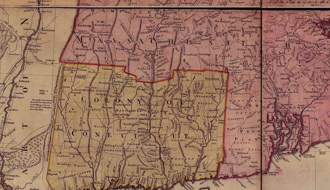
Why Does Connecticut’s Northern Border Have a Notch?

If you look at a Connecticut map, you’re likely to notice a small notch in the state’s border with Massachusetts. The border runs east-west, takes a slight jog to the south, slides east-west, heads back north, and resumes its east-west pathway.
Overall, there are a little over two square miles that sit in Massachusetts but look like they belong in Connecticut.
Exploring the reason why uncovers a compromise between Connecticut and Massachusetts that came after five surveys and more than 160 years of border disputes that saw both states claiming land and residents of four towns switching states.
The First Border Dispute
The first Connecticut/Massachusetts border dispute followed a 1642 survey that, by any objective measure, was wildly inaccurate.
As the Massachusetts and Connecticut colonies were settled, the border between the states didn’t matter all that much. Most people established new towns on coastlines, and the area in north-central Connecticut only had scattered settlements.
In 1642, Massachusetts hired two surveyors, Nathaniel Woodward and Solomon Saffery, to define the commonwealth’s border with Connecticut. Under its royal charter, Massachusetts’ southern border started three miles south of the most southerly branch of the Charles River and extended west to the Pacific Ocean.
Woodward and Saffery found the starting point easily but botched the rest of the survey. Instead of moving west over land as they should have, they sailed around Cape Cod and traveled north up the Connecticut River until they thought they reached the latitude where the border should’ve been. They started surveying the lands to the west using the proper technique.
At their best, their line was two miles too far south. At its worst, their line was off by eight miles.
Massachusetts accepted the border and its new land. Connecticut, for its part, couldn’t say a lot at the time because, unlike Massachusetts, it hadn’t yet received a royal charter and its settlers were, for intents and purposes, squatters.
The next dispute followed a 1695 survey hired by Connecticut (which now had a charter) that determined the border should’ve been placed north of the 1642 line. The reaction from Massachusetts was a condescending chuckle as it ignored the new survey.
Another survey in 1702 by surveyors representing both states confirmed the border established by the 1695 survey. Massachusetts chose to ignore that survey as well.
The states formed a joint commission in 1713 to debate which state would control the towns that had been settled in the disputed land. The commission hired yet another survey that largely agreed with the second and third surveys, which placed several Massachusetts towns within the borders of Connecticut.
As a compromise, those towns were assigned to Massachusetts, with Connecticut receiving other land as compensation.
Migrating Towns
The border question between the two states took another turn in 1724 when the Massachusetts towns of Enfield, Somers, Suffield, and Woodstock decided they’d rather be in Connecticut, where taxes were lower (it’s not often you can type that clause).
Connecticut voted to accept the communities in 1749, and the resulting arguments continued until the towns formally joined Connecticut in 1797.
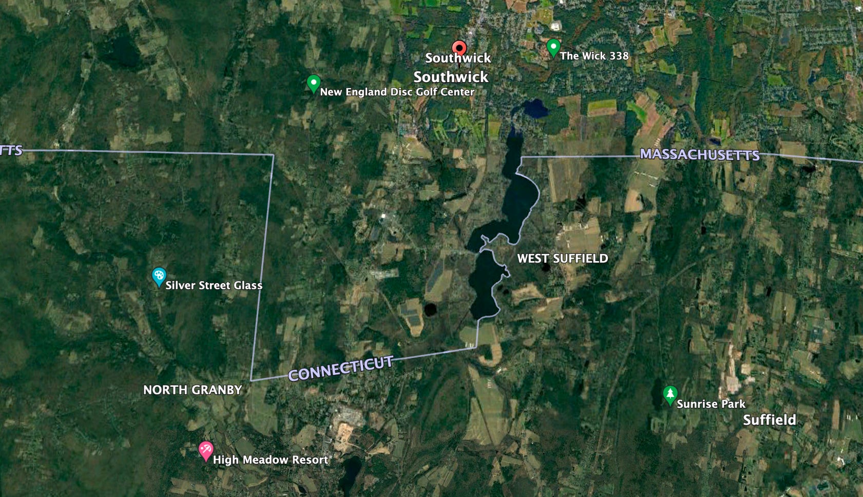
In 1804, Connecticut and Massachusetts reached an agreement on the border we see today. The southern half of the border town of Southwick, Massachusetts, was divided at the Congamond Lakes to place the lakes in Massachusetts. The border traces the shoreline on the east, runs 2.6 miles east-west, and jogs nearly 2.7 miles north-south before resuming its east-west path along the 1713 line.
Border Disputes Continue
While the borders between U.S. states seem like they should be long settled, there’s a handful of active disputes today. A 1941 report suggests a series of errors in the 1839 border between Connecticut and Rhode Island places 68 acres, and several homes, incorrectly in Rhode Island. So far, officials in both states have shrugged their shoulders as local tax assessors look at homes on the other side of the line.
And where a state or municipality draws its borders matters for two main reasons; tax revenue and water rights. Which side of a border where a big box retailer sits, for instance, determines which city or two receives property tax revenue and which state collects sales tax.
In 1989, Texas built a water pumping station on Lake Texoma that wound up in Oklahoma after the state line was redrawn. Officials from both states are discussing options including redrawing the redrawn border, or swapping about an acre of land between the states to include the pumping station.
Similarly, Georgia and Tennessee have been arguing about the border between the two states for nearly two centuries. The line was supposed to sit on the 35th parallel of latitude, but an 1826 surveying error placed the border a few feet south of the intended line. As a result, Georgia can’t access water from the Tennessee River that, had the line been placed correctly, would flow through its state.
Meanwhile, the waters of the Congamond Lakes remain firmly in Massachusetts. Thanks to a weird notch in a state line.